
Why Does Mount Batur Have Black Lava Fields? Understanding Bali’s Volcanic Landscape
One of the most striking sights around Mount Batur is the dark, rugged ground that spreads across parts of the caldera. At first glance, the black rocks can look like a vast field of charcoal or broken pavement. They are not ordinary stones, however. Much of this dramatic terrain is associated with past volcanic activity, when molten rock reached the surface, cooled and became the lava landscape visitors see today.
Understanding how these fields formed adds another layer to a visit to Kintamani. The scenery is not simply a backdrop for photographs; it is a visible reminder that Mount Batur is an active volcanic system that has shaped the surrounding area over a long period of time.
What Are the Black Lava Fields Around Mount Batur?
A lava field is an area covered by lava that flowed from a volcanic vent or opening and later solidified. When molten rock emerges during an eruption, it moves across the ground according to its temperature, thickness, slope and the shape of the landscape. As it loses heat, the material hardens into volcanic rock.
The dark surface around Mount Batur is commonly associated with basaltic volcanic material. Fresh or relatively unweathered basalt often looks black or very dark grey. Over time, exposure to rain, sunlight, wind and biological activity can change its colour and texture. Some sections remain rough and broken, while others become smoother or partly covered by soil and vegetation.
How Does Molten Lava Become Solid Rock?
Inside a volcano, molten rock is called magma. When it reaches the Earth’s surface, it is called lava. During an eruption, lava can spread away from an opening and follow lower ground. It does not always move like a fast river. Some flows advance slowly, while others can travel more quickly depending on their properties and the terrain.
The outside of a lava flow begins to cool when it comes into contact with the air and the cooler ground. A solid crust can form while hotter material continues moving beneath it. As the flow loses more heat, it eventually becomes solid rock. The result may be a jumble of sharp, uneven blocks, a rough surface, or a more compact sheet of rock.
This is why a lava field can look so different from one section to another. The shape records how the lava travelled and cooled, as well as what happened to the rock after the eruption ended.
Why Is the Ground So Dark?
The colour is largely related to the minerals in the volcanic rock. Basalt typically contains minerals rich in iron and magnesium, which give fresh surfaces a dark appearance. When the rock breaks, the newly exposed interior can look almost black, especially in strong sunlight or after rain.
Not every dark patch is necessarily a recent lava flow, and not every volcanic deposit has the same composition. Volcanic landscapes can include lava, ash, lapilli and other erupted material. These deposits form in different ways, so a dark surface should not automatically be described as a single type of volcanic rock.
Mount Batur’s Eruptions and the Changing Caldera
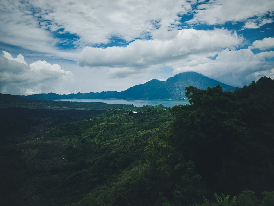
Mount Batur sits within a large volcanic caldera in the Kintamani area of Bali. A caldera is a broad volcanic depression that forms when the ground collapses after a major eruption or the withdrawal of magma beneath a volcano. The wider Batur landscape includes the volcanic cone, Lake Batur, surrounding ridges and areas affected by earlier eruptions.
Mount Batur has experienced multiple eruptions throughout recorded history. One of the best-known eruptive periods occurred in 1963, when volcanic activity produced lava and other deposits that changed parts of the landscape. Later activity has also been recorded. The exact appearance of the terrain today reflects more than one episode of volcanic activity, together with decades of weathering and human use of the area.
For a scientific overview of the volcano and its recorded activity, visitors can consult the Smithsonian Global Volcanism Program and its volcano records. Always rely on current local authorities for information about access restrictions and volcanic alerts.
Why Does Vegetation Grow Slowly on Some Lava Fields?
Solid lava is not the same as ordinary garden soil. Newly exposed rock has very little loose material in which plants can take root, and water can drain quickly through cracks. Sun-exposed surfaces may also become hot during the day. These conditions make it difficult for many plants to establish themselves immediately.
Over time, the rock breaks down through physical and chemical weathering. Dust, organic matter and small particles collect in cracks and low areas. Mosses, grasses and other hardy plants may begin to grow where enough moisture and material accumulate. Gradually, these small patches can develop into more established vegetation.
The process is not uniform. A sheltered crack may support plants while a nearby exposed rock surface remains almost bare. This contrast is part of what makes the caldera visually interesting: dark volcanic ground, green vegetation and the surrounding mountain scenery appear side by side.
What Can Visitors See in the Batur Volcanic Area?
Exploring the Kintamani area offers more than a view of one mountain peak. Depending on the route and conditions, visitors may see dark volcanic deposits, rugged slopes, the broad caldera, Lake Batur and villages that have adapted to life in this mountain environment. The scenery changes with the weather and the angle of the light.
Some visitors explore the area by vehicle, while others experience the mountain on foot during a sunrise trek. A trekking route is not a free-roaming path across every lava field, so follow the guide’s chosen route and any local access instructions. If you are planning a sunrise hike, you can learn more about the Mount Batur sunrise trekking experience and check the available options before choosing a trip.
Tips for Exploring a Volcanic Landscape Safely
Volcanic ground can be uneven, sharp and loose underfoot. Even a short walk may feel different from walking on a paved path. A few simple precautions can make the visit more comfortable:
- Wear closed-toe footwear. Shoes with a firm grip help on loose gravel and rough rock.
- Watch where you step. Avoid rushing across broken lava, loose stones or unfamiliar ground.
- Stay on permitted routes. Do not enter restricted areas, climb unstable rock faces or approach volcanic openings.
- Follow local guidance. Conditions and access rules can change, especially when volcanic activity increases.
- Bring water and sun protection. Some exposed sections offer little shade during the day.
- Leave the landscape as you found it. Do not remove rocks, damage plants or leave rubbish behind.
Frequently Asked Questions
Are the black rocks around Mount Batur made from lava?
Many dark rocky areas in the Batur volcanic landscape are associated with solidified lava. The wider area also contains other volcanic deposits, so not every dark or loose surface is necessarily a lava flow.
Can visitors walk on the Mount Batur lava fields?
Access depends on the specific location, current conditions and local rules. Only explore areas where visitors are permitted, and follow a local guide or the instructions provided by the relevant authorities.
Is Mount Batur still an active volcano?
Yes. Mount Batur is an active volcano with a history of repeated eruptions. Visitors should check current official volcanic information and follow any access restrictions before travelling.
Why are some parts of the lava field covered with plants?
Weathering gradually breaks volcanic rock into smaller particles. Soil and organic matter can collect in cracks, allowing hardy plants to grow. This process takes time and varies from place to place.
Discover the Story Behind Bali’s Volcanic Scenery
The black lava fields around Mount Batur are a reminder that Bali’s landscape is continually shaped by natural forces. What looks like a rough stretch of dark rock is part of a much longer geological story: molten material reached the surface, cooled into stone, and slowly began to change through weathering and the return of vegetation.
Whether you admire the caldera from a viewpoint or explore the mountain with a guide, taking time to understand the landscape can make the experience more meaningful. If a sunrise adventure is part of your Bali plans, visit our Mount Batur tour and trekking booking page to review the current options and arrange your visit.