

How Was the Batur Caldera Formed? The Geological Story Behind Bali’s Volcanic Landscape
The wide mountain landscape around Mount Batur is more than a beautiful part of Bali. It is the result of powerful geological events that took place over a very long period of time. The broad basin, steep caldera walls, volcanic cones and Lake Batur all tell part of the story of how this region developed.
To understand the scenery of Kintamani, it helps to understand one important geological feature: a caldera. Mount Batur is located within a large volcanic caldera, a landform created by major volcanic activity and the collapse of the ground above a partly emptied magma system. This is different from the smaller crater usually seen at the top of a volcano.
What Is a Volcanic Caldera?
A caldera is a large, basin-shaped volcanic depression. It can form when a major eruption removes a substantial amount of magma from beneath a volcano. When the underground support is reduced, the rock above may sink or collapse along fractures, creating a broad depression.
Calderas are usually much wider than ordinary volcanic craters. A crater is commonly a relatively small opening or bowl-shaped feature around a volcanic vent. A caldera can extend across many kilometres and may contain newer volcanic cones, lakes, villages and other landscape features.
The Batur region is a good place to appreciate this difference. The landscape is not simply one cone with a crater at its summit. It is a much larger volcanic basin with a complex history and younger volcanic features inside it.
How Was the Batur Caldera Formed?
The formation of a large caldera is a process, not a single moment that can be understood from its present-day shape alone. In general, magma accumulates beneath a volcanic area. During a major explosive eruption, large volumes of magma and fragmented volcanic material can be released. As the underground magma reservoir loses support, sections of the surface may subside and form a broad depression.
Geological studies describe the Batur area as having a complex history that includes major caldera-forming eruptive events. The broad depression and its surrounding rim are evidence of this long volcanic development. Later eruptions built new volcanic features within the older caldera, which is why the present landscape contains more than one generation of volcanic landforms.
It is important not to imagine the caldera as a perfectly circular hole created in one simple explosion. Real volcanic systems are complicated. Eruptions, ground collapse, lava emplacement, erosion and the gradual rebuilding of volcanic cones can all contribute to the landscape seen today.
Why Are There Two Distinct Caldera Rims?
One striking feature of the Batur landscape is the presence of broad caldera boundaries that give the area a nested appearance. The wider outer landscape and the younger inner volcanic features reflect different stages in the region’s geological history.
Over time, repeated volcanic activity can reshape an older caldera. New eruptions may create cones and deposits inside an existing depression, while erosion gradually modifies the surrounding slopes. The result is a landscape with overlapping volcanic structures rather than one simple crater.
When looking across the region, visitors may notice ridges and curved mountain lines that help define the caldera. These features are easier to understand from a broad viewpoint than from a single trail, because the scale of the landform becomes more apparent when the surrounding basin is visible.
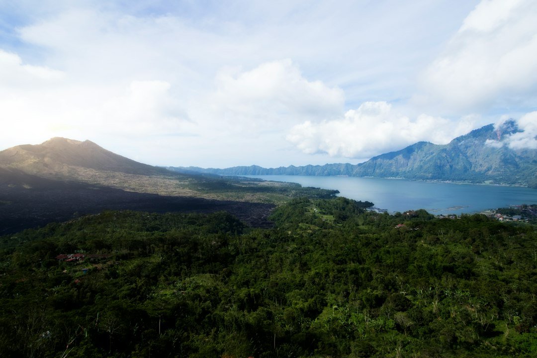
How Did Lake Batur Form Inside the Caldera?
Lake Batur occupies part of the volcanic depression and is one of the most recognisable features of the Kintamani landscape. Its position within the caldera gives visitors a clear sense of the scale of the basin and the relationship between the lake, the surrounding ridges and Mount Batur.
Volcanic calderas can become natural basins where water collects. The development of a lake depends on several factors, including the shape of the depression, rainfall, groundwater movement, drainage and the permeability of the underlying rocks. The lake and its surroundings have also been shaped by natural processes and human activity over time.
Lake Batur is not simply a decorative feature beside the volcano. It is part of the wider environment that supports local communities, agriculture and tourism. Its presence also makes the caldera easier to recognise when viewed from elevated points around Kintamani.
Mount Batur Is a Younger Volcano Within an Older Landscape
The name Mount Batur is often used for the prominent volcanic cone that rises within the caldera. However, the geological story of the area is much older and more extensive than the visible summit. The present cone developed within a landscape that had already been shaped by earlier volcanic events.
This helps explain why the region contains several kinds of volcanic scenery. Visitors may see a recognisable mountain cone, broad slopes, rugged deposits and the larger caldera rim in the same panorama. Each feature represents a different part of the area’s volcanic history.
For another part of this story, read our guide to why Mount Batur has black lava fields. That article looks more closely at how lava flows cool and become solid volcanic rock, while this guide focuses on the much larger landform that surrounds the mountain.
How Has the Caldera Changed Since Its Formation?
A caldera does not remain unchanged after it forms. Rainfall, streams, landslides and the gradual breakdown of rock reshape its slopes. Plants establish themselves where soil and moisture are available. Later volcanic eruptions can add new layers of ash, lava and other deposits, changing the surface again.
People have also become part of the modern landscape. Settlements, farming areas, roads and visitor viewpoints occupy parts of the caldera region. The communities around Lake Batur have developed ways of living with the area’s mountain environment, while tourism has introduced more visitors to its natural and cultural significance.
The black volcanic ground seen in some locations is one visible result of this continuing geological story. Its texture and appearance vary depending on the type of deposit, its age and the effects of weathering. The caldera itself, however, is a much larger feature than any individual lava field.
Where Can You See the Batur Caldera Landscape?
There are several ways to appreciate the scale of the Batur caldera. Viewpoints around Kintamani provide broad panoramas of the mountain, lake and surrounding ridges. From these locations, the relationship between the inner volcanic features and the wider basin is easier to understand.
A sunrise trek on Mount Batur offers a different perspective. As daylight develops, the shapes of the surrounding landscape gradually become clearer. The experience is primarily a mountain walk, so the view depends on weather, visibility, the route and the conditions on the day. Visitors should follow their guide and remain on permitted paths.
Is the Batur Caldera Still Volcanically Active?
Yes. Mount Batur is an active volcanic system, even though the caldera itself was formed by much older geological events. Volcanic activity can include earthquakes, gas emissions and eruptions, and the level of activity can change over time.
Visitors should never use an old travel article or a photograph as an indication that an area is safe to enter. Before travelling, check current information from Indonesia’s official geological and disaster-monitoring authorities, and follow any restrictions announced by local officials. The Smithsonian Global Volcanism Program profile for Batur is also a useful reference for background information about the volcano and its recorded activity.
Frequently Asked Questions About the Batur Caldera
Is Mount Batur located inside a caldera?
Yes. The visible Mount Batur volcanic cone is located within the larger Batur caldera in the Kintamani area of Bali.
What is the difference between a caldera and a crater?
A crater is generally a smaller depression around a volcanic vent. A caldera is a much larger basin that commonly forms when the ground above a partly emptied magma reservoir collapses after major volcanic activity.
Is Lake Batur inside the caldera?
Yes. Lake Batur occupies part of the broad volcanic depression and is one of the defining features of the Batur caldera landscape.
Can you see the whole caldera from Mount Batur?
Some sections of the caldera and Lake Batur can be seen from suitable viewpoints on or around the mountain. The exact view depends on the route, weather and visibility. A viewpoint around Kintamani may provide a broader panorama of the surrounding basin.
Is it safe to visit the Batur caldera?
Visiting permitted viewpoints and established routes can be part of a normal trip, but Mount Batur is an active volcano. Always check current official advisories, obey access restrictions and follow local guidance before entering the area.
Explore Mount Batur Beyond the Summit View
Understanding the Batur caldera changes the way you see the landscape. The mountain, lake and surrounding ridges are connected parts of a much longer geological history. What looks like a simple mountain view is actually a record of major eruptions, ground collapse, later volcanic growth and the gradual work of nature.
If you would like to experience the area in person, explore our Mount Batur sunrise trekking information or check the available trekking and tour options. Choose a permitted route, follow local guidance and take time to appreciate the remarkable landscape of Kintamani.