

Walking the Black Lava Field: Mount Batur’s 1963 & 1974 Eruptions
Halfway through the descent from the summit, the trail suddenly changes. The loose grey gravel under your boots turns jet black. The rocks become jagged, twisted, and sharp. You have just stepped onto the frozen remains of two eruptions that reshaped the mountain in living memory — the black lava fields of 1963 and 1974. For many trekkers, this is the most surreal part of the entire morning.
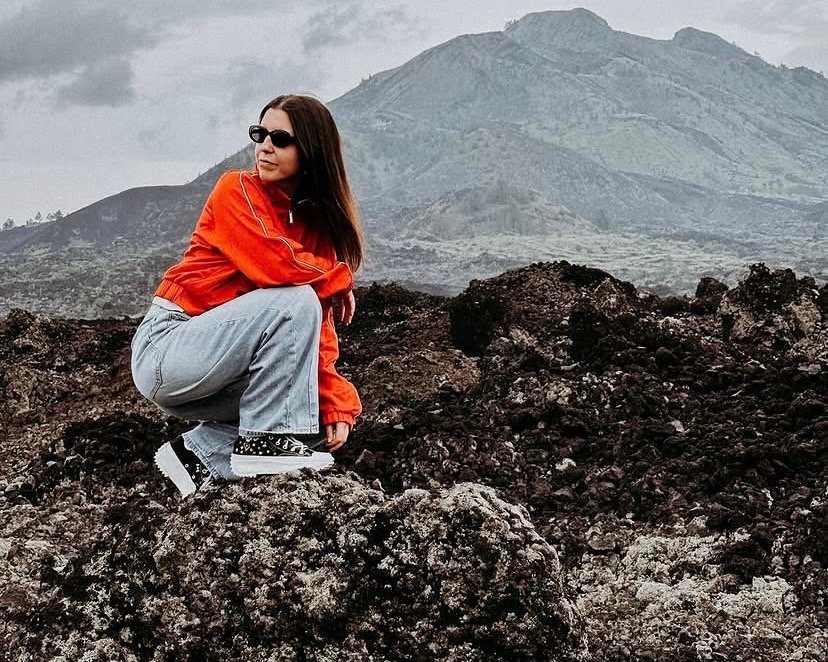
Walking across a lava field feels like landing on another planet. There is no soil, no grass, no trees — just black rock sculpted by 1,000°C magma that cooled into waves, ropes, and razor edges. Photographers lose their minds here. Jeep tour guests get the best angles without burning their boots. And everyone walks away with a deeper understanding of what an active volcano actually does to a landscape. Here is the story written in stone under your feet. Ready to see the black lava field in person? Let’s break down the geology.
The Two Eruptions That Built the Field
The black lava field you cross is actually two distinct flows, stacked and side-by-side, from two separate eruptions. Both are documented in detail by the Smithsonian Global Volcanism Program, and both are still visible today because volcanic rock weathers extremely slowly in this climate.
1963: The Big One
On March 17, 1963, Mount Agung — Bali’s highest and most sacred volcano, visible from Batur’s summit — erupted catastrophically. The eruption killed over 1,000 people and sent pyroclastic flows down Agung’s slopes. But the seismic shock also triggered activity at Mount Batur, 20 km to the northwest.
Batur’s 1963 eruption was smaller and less deadly, but it produced a significant lava flow on the northwestern flank of the inner cone. This is the older, slightly more weathered section of the black field you walk across. In some places, pioneer plants have started to colonize cracks in the rock — the first stage of an ecological recovery that takes centuries.
1974: The Fresh One
Eleven years later, Batur erupted again — this time from the main summit crater. The 1974 flow was more fluid and covered a larger area, spilling down the southwestern flank where most trekkers descend today. This lava is darker, sharper, and less weathered. It forms the dramatic twisted shapes that dominate photographs of the field.
The 1974 flow also destroyed the original summit temple and several farming terraces inside the caldera. The temple was rebuilt higher up, and the farmers moved to safer ground — a quiet reminder that this is not a museum piece, but a living volcano.
What You’re Actually Walking On (The Geology)
The black rock has a name: aa lava (pronounced “ah-ah,” supposedly because that’s what you yell when you walk across it barefoot). It forms when viscous, gas-rich lava flows slowly and fractures into jagged blocks as the crust cools and breaks. Every twisted spike and sharp edge you see was once liquid at around 1,000–1,100°C.
Contrast this with pahoehoe lava — the smooth, ropey kind you see in Hawaii. Batur rarely produces pahoehoe because its magma is slightly more silica-rich and gas-heavy. So the lava field is almost entirely aa: sharp, clinkery, and unforgiving under thin-soled shoes.
That’s why closed-toe hiking shoes are non-negotiable on any Batur trek — see the full footwear breakdown in our Mount Batur outfit guide. Flip-flops on aa lava are how you lose a toenail before breakfast.
The Trekking Experience: Crossing the Field on Foot
For trekkers, the black lava field appears on the descent (and sometimes on the final 30-minute summit push, depending on the route). Your guide will lead you along a cairn-marked path through the sharpest sections, but there are moments where you’re stepping directly onto the raw 1974 flow.
This is where knees and ankles get tested. Aa lava shifts underfoot, and the uneven surface is rougher than the gravel sections above. Trekking poles — which we provide — earn their keep here. The reward is the visual: morning light raking across the black rock throws dramatic shadows, and steam sometimes still rises from cracks where groundwater meets residual volcanic heat.
For the full hour-by-hour flow of the trek, including when you hit the lava field, see our complete Mount Batur trekking guide.
The Jeep Experience: Lava Field by 4×4
Here’s where the Mount Batur jeep sunrise tour has a real advantage. The jeep doesn’t just drive past the lava field — it drives into it. A designated 4×4 track cuts across the 1974 flow, and your driver parks at three or four specific photo spots that trekkers on foot rarely reach.
You’ll stand on elevated lava ridges with the black rock stretching out below you, the inner cone of Mount Batur rising behind, and the caldera rim framing the scene. At sunrise, the golden light hitting the black rock is one of the most striking images in Bali — and you get it without a single step of hiking.
Photographers specifically book the jeep tour for this section. Tripod-friendly angles, no crowds, and the ability to shoot the field at multiple times as the light changes. If you’re coming with a serious camera, the jeep often delivers a better portfolio than the trek. The full trek vs jeep comparison is in our trekking vs jeep guide.
The Best Photo Spots (And When the Light Hits)
If photography is your priority, here’s what the light does on the black lava field through the morning:
- 05:30 – 06:00 (pre-sunrise): Deep blue hour. The black rock reads as a silhouette against the brightening sky. Great for moody wide shots, especially with a headlamp in frame.
- 06:00 – 06:30 (sunrise): Golden side light rakes across the aa formations. Shadows stretch long, textures pop. Peak photography window. For the full settings breakdown per light window — stars, blue hour, sunrise burst, and golden caldera — read our Mount Batur sunrise photography field guide.
- 06:30 – 07:30 (post-sunrise): Light becomes flat and overhead. The lava field loses its drama. This is when most trekkers have already moved on.
- 07:30 – 08:30 (descent): The light shifts again as you drop lower. Steam from residual heat sometimes catches morning sun — rare but spectacular when it happens.
Trekkers get the 05:30–06:30 window near the summit. Jeep guests can extend into the 07:00+ window at the lower lava field stops because they don’t have to hike down. That extra hour is often where the best images come from.
Respecting the Field (UNESCO Rules in Action)
Because the entire caldera is part of the Batur UNESCO Global Geopark, the lava field is protected. Three rules apply to every visitor, whether trekking or in a jeep:
- Stay on marked paths. Straying off-trail damages fragile rock formations that took decades to stabilize.
- Don’t take rocks home. Every piece of aa lava is part of the geological record. It’s also illegal under Geopark regulations.
- Don’t stack cairns. Cairns mark the safe path. Rearranging them creates a hazard for the next group walking in the dark.
Our guides enforce these rules gently but firmly. The lava field has survived 50+ years of tourism because of this collective respect — keep it that way.
Frequently Asked Questions
Is the lava field hot to walk on?
At the surface, no. The 1974 rock has cooled to ambient temperature. But in a few specific cracks, residual geothermal heat still reaches the surface — you may see faint steam rising on cold mornings. Your guide knows exactly where these are and will point them out safely.
Can I touch the lava?
Yes, once it’s cooled. The 1974 aa lava is safe to touch and climb on. Just mind the sharp edges — they cut skin easily. Closed-toe shoes and long pants are strongly recommended.
Is the lava field dangerous?
Not when the volcano is at Normal status (Level 1), which is the current condition. The danger is physical, not volcanic: twisted ankles on uneven aa, or sunburn from the unshaded rock reflecting heat. Trekking poles and sunscreen solve both.
Which format shows more of the lava field?
The jeep tour. Jeeps access parts of the 1974 flow that trekkers don’t cross because the trail bypasses them to reach the summit faster. If lava field exploration is your priority, book the jeep sunrise tour.
Can I bring a drone over the lava field?
Drone flights are restricted in the Geopark without a permit. Commercial shoots require advance approval. Recreational small drones are sometimes tolerated at the guide’s discretion, but they cannot fly near the crater or over crowds. Check with your guide the night before.
Will my shoes get ruined?
Aa lava is abrasive. Your shoes will get dusty, scuffed, and possibly scratched. Don’t bring your favorite pair. A sturdy pair of trail runners or older sneakers works perfectly — details in our full outfit guide.
Frozen Fire, Living Mountain
Fifty years ago, the 1974 flow was a river of liquid fire tearing down the mountain’s flank. Today it is a silent, black sculpture park where you eat breakfast with a volcano in the background and steam rising from cracks in the rock. That contrast — between what this field was and what it is now — is what makes the Batur experience stick with people for years.
Whether you cross it on foot or in a 4×4, the lava field is where the mountain stops being a postcard and becomes a geology lesson you can touch.
Browse our sunrise trek and jeep packages — every outing includes the lava field experience, with the format you choose determining how deep into it you go. Bring closed-toe shoes. The aa will thank you by not cutting your feet.